A very poor summer month
Usually even in the poorest of summer months there would be at least one or two days that manage to imitate 'something summery', but not this one! Not a single day in July could be described thus. It was a truly awful month that saw rain, heavy at times, become a frequent visitor and day-time maxima that were heavily suppressed.
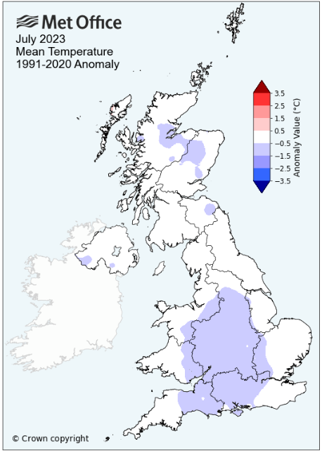
With the Jet Stream on a meandering route to our south, it left the UK to its north and at the mercy of low pressure systems; whilst much of Europe suffered with excessive heat, we endured rain and cool day-time temperatures. With the skies often being cloudy, the mean minimum temperature for the month held up very well, in fact finishing above average, but the same could not be said for the mean maximum temperature. With a lack of sunshine this was heavily suppressed and finished 1.54°c below average and during the month only four days would attain 20°c and 26 days would fail to attain the seasonal average of 19.7°c.
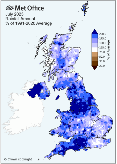
The first seven days of the month were actually very dry, but from the 8th there would only be one more dry day and some of the daily falls were quite heavy. As with the 14-15th and 22nd-23rd it was also a case of heavy falls over a two day period. The month finished as the second wettest in my records.
In spite of low pressure (LP) surrounding the UK, the start of the month was relatively quiet with little rainfall (just 1.8 mm) during the 1st to 7th. However, it was fairly windy, mainly cloudy with little sun and the day-time maxima were very disappointing; the first five days didn't get above 17°c and were generally stuck between 15.5° and 16.5°c.
Then it started to get wet! From the 8th (apart from the 24th) some rain was recorded on every day as a succession of LP systems visited our part of the world and took control of the weather. The rain wasn't always heavy, but there were still some large daily falls with daily maximum temperatures consistently stuck below average.
However, the three days of the 7-9th all managed to top 20°c. The 7th did manage a sunny afternoon which saw the temperature rise to a month's high of 24.7°c, which was then repeated on the 8th, but which coincided with the start of the 'wet spell'. The rain arrived early afternoon with a spell of thunder and lightning at 17h with heavy showers and/or spells of heavy rain throughout the evening. The rain continued overnight into the 9th, heavily through to 0230h and with more lightning; a total fall of 27.1 mm being recorded.
The next few days saw a mix of showers and some sunny intervals, until the 14th when an area of LP in Biscay deepened and moved north, tracking north through Eire. However, its associated fronts brought us a couple of wet days, 17.4 mm on the 14th was followed by 21.1 mm on the 15th.
It was a return to the mix of cloud, showers and some sunny intervals over the next few days, but with the 18th being especially poor as a shallow area of LP with active fronts moved across the UK from the SW. It rained just about all day, although just 7.4 mm was recorded, but it was more notable for providing a maximum temperature of just 14.9°c (58.8°f).
The 20th did see some sunny intervals, but even then the temperature failed to attain 20°c and now the next few days would generally be described as 'bleak', they were also the first weekend of the school holidays! Friday 21st saw variable amount of cloud with some showers (8.0 mm) and then the Saturday (15.5 mm) saw rain from 09h with drizzle a.m. but whilst the afternoon was dry, it was totally grey and murky. The majority of the rain for the 22nd fell overnight into the 23rd and it just kept on raining all day (putting an end to England's chances in 'The Ashes') and which gave another 18.5 mm. Whilst the nights were mild, the days weren't, both the 21st and 22nd were stuck at just over 17°c, but the 23rd was a miserable and cool 15.0°c.
The 24th provided is with the rarity of a dry day, but behind the fronts of the 23rd, we were exposed to NW'ly flow and a maximum of just 16.4°c ... and then the rain returned!
The final five days of the month were certainly mild ... by night. Under endless cloudy skies a lid was kept on the temperature falling away at night, problem was, it didn't have that far to fall from! During the 27th to 30th LP in the Atlantic became almost stationary and whilst the rainfall totals were only slight, the depression of grey, overcast skies, some rain and temperatures that were down at 17°c, finally brought a poor month to a close.
MSLP of 1007.5 Mb was -6.5 MB below average for the month and overall a mean minimum of 11.19°c and a mean maximum of 18.15°c saw the temperature 0.51°c below the fourteen year average for this site.
It was the coldest July since 2020 and since the record began (2009), seven have been warmer and seven colder - the highest maximum temperature recorded during the month being 24.7°c (7+8th), the lowest minimum 6.9°c (20th).
Rainfall of 155.9 mm (Maulds Meaburn North 155.9 mm -- Castlehowe Scar 203.3 mm) was 160.2% of average for 2007-22, making it the wettest July since 2009 and since the record began (2007), fifteen have been drier and one wetter.
During the month the following 'days of' were recorded: Thunder on two days -- the wind speed averaged 5.45 mph, with a maximum gust of 39 mph (1st).
We had 0 Air Frosts in the month (year 32) -- Grass Frosts totalled 0 (year 64).
The 1 foot soil temp ranged from a low of 16.1°c on the 3rd and 5-6th to a high of 17.5°c on the 10th -- with a monthly mean of 16.7°c
The 1 meter soil temp ranged from a low of 14.5°c on the 7-8th to a high of 15.3°c on the 24th -- with a monthly mean of 14.9°c
This makes the Jan' to July period of 2023 0.81°c warmer than the average for 2009-22 and with 97.8% of average rainfall for 2008-22
At the Met' Office site at Shap a mean minimum of 10.7°c and a mean maximum of 17.5°c saw the monthly mean temperature 0.05°c above average. It was the coldest July since 2020 and since the record commenced (1992), 13 have been warmer, 15 colder, two were the same and there is no data for one year.
Rainfall of 183.8 mm represents 172.3% of its average. It was the wettest July since 2010 and in a record that commenced in 1989, 32 have been drier and two have been wetter.
Cumbria Rainfall
Whilst the first week of the month was actually quite dry, the remainder of the month was anything but and which saw a number of sites record well in excess of double their LTA. In what was a very wet month only a handful of sites recorded less than 150% of their LTA, with no site recording less than the 140% found at Aisgill.
The wettest parts of the county tended to be in the more northerly parts, Abbeytown in the NW recording 252.4% of its LTA, but 'wet pockets' did pop up elsewhere in central and eastern parts, but not on the western coastal fringe and unusually no site finished with a total fall below 100mm.
Ulverston with a total fall of 111.2 mm had the lowest monthly total, rising to 502.8 mm at Ennerdale Black Sail and whilst the 15th was a very wet day across the county, it was particularly so within the LDNP where 87.4 mm fell at Honister (not the greatest UK 24Hr fall which this month fell in Devon and topped 100mm).
Reservoir Storage - in response to the heavy rainfall in July total reservoir storage for North West England increased from 70% at the end of June to 74% at the end of July. At the end of July reservoir storage (in terms of percentage) was highest at Crummock and Ennerdale which were both at 100% full. Storage was lowest at Rivington at 59.8%. The combined storage at Haweswater and Thirlmere was 62.2% at the end of July which is higher than the level in 1995 and 2021 and at the average for the time of year.
Figures from the Environment Agency's rainfall sites were, (figure in brackets being the monthly average for 1991-2020) 'Data kindly provided by the Hydrometry and Telemetry team of the Environment Agency (Penrith)':
At Appleby in Westmorland rainfall of 128.8 mm (LTA of 75.0 mm) represents 171.7% of its average (1856-2022) and made it the wettest since 2009 - since the record commenced (1856), 154 have been drier, 13 have been wetter and one was exactly the same.
Kirkby Thore ??? mm -- (64.7 mm)
Haresceugh Castle (Kirkoswald) 172.12 mm -- (89.1 mm)
Brothers Water 314.56 mm -- (161.3 mm)
Seathwaite Farm (Borrowdale) 426.4 mm -- (228.2 mm [average for 1845-2022]) - making it the wettest since 2020 and since 1845 when the record commenced, 168 have been drier and 10 have been wetter.
JANUARY 2010
FEBRUARY 2010
MARCH 2010
APRIL 2010
MAY 2010
JUNE 2010
JULY 2010
AUGUST 2010
SEPTEMBER 2010
OCTOBER 2010
NOVEMBER 2010
DECEMBER 2010
JANUARY 2011
FEBRUARY 2011
MARCH 2011
APRIL 2011
MAY 2011
JUNE 2011
JULY 2011
AUGUST 2011
SEPTEMBER 2011
OCTOBER 2011
NOVEMBER 2011
DECEMBER 2011
JANUARY 2012
FEBRUARY 2012
MARCH 2012
APRIL 2012
MAY 2012
JUNE 2012
JULY 2012
AUGUST 2012
SEPTEMBER 2012
OCTOBER 2012
NOVEMBER 2012
DECEMBER 2012
SUMMER 2012
REVIEW OF 2012
JANUARY 2013
FEBRUARY 2013
MARCH 2013
APRIL 2013
MAY 2013
JUNE 2013
JULY 2013
AUGUST 2013
SEPTEMBER 2013
OCTOBER 2013
NOVEMBER 2013
DECEMBER 2013
REVIEW OF 2013
JANUARY 2014
FEBRUARY 2014
MARCH 2014
APRIL 2014
MAY 2014
JUNE 2014
JULY 2014
AUGUST 2014
SEPTEMBER 2014
OCTOBER 2014
NOVEMBER 2014
DECEMBER 2014
WINTER 2014
REVIEW OF 2014
JANUARY 2015
FEBRUARY 2015
MARCH 2015
APRIL 2015
MAY 2015
JUNE 2015
JULY 2015
AUGUST 2015
SEPTEMBER 2015
OCTOBER 2015
NOVEMBER 2015
DECEMBER 2015
REVIEW OF 2015
JANUARY 2016
FEBRUARY 2016
MARCH 2016
APRIL 2016
MAY 2016
JUNE 2016
JULY 2016
AUGUST 2016
SEPTEMBER 2016
OCTOBER 2016
NOVEMBER 2016
DECEMBER 2016
REVIEW OF 2016
JANUARY 2017
FEBRUARY 2017
MARCH 2017
APRIL 2017
MAY 2017
JUNE 2017
JULY 2017
AUGUST 2017
SEPTEMBER 2017
OCTOBER 2017
NOVEMBER 2017
DECEMBER 2017
REVIEW OF 2017
JANUARY 2018
FEBRUARY 2018
MARCH 2018
APRIL 2018
MAY 2018
JUNE 2018
JULY 2018
AUGUST 2018
SEPTEMBER 2018
OCTOBER 2018
NOVEMBER 2018
DECEMBER 2018
REVIEW OF 2018
JANUARY 2019
FEBRUARY 2019
MARCH 2019
APRIL 2019
MAY 2019
JUNE 2019
JULY 2019
AUGUST 2019
SEPTEMBER 2019
OCTOBER 2019
NOVEMBER 2019
DECEMBER 2019
REVIEW OF 2019
JANUARY 2020
FEBRUARY 2020
MARCH 2020
APRIL 2020
MAY 2020
JUNE 2020
JULY 2020
AUGUST 2020
SEPTEMBER 2020
OCTOBER 2020
NOVEMBER 2020
DECEMBER 2020
REVIEW OF 2020
JANUARY 2021
FEBRUARY 2021
MARCH 2021
APRIL 2021
MAY 2021
JUNE 2021
JULY 2021
AUGUST 2021
SEPTEMBER 2021
OCTOBER 2021
NOVEMBER 2021
DECEMBER 2021
REVIEW OF 2021
JANUARY 2022
FEBRUARY 2022
MARCH 2022
APRIL 2022
MAY 2022
JUNE 2022
JULY 2022
AUGUST 2022
SEPTEMBER 2022
OCTOBER 2022
NOVEMBER 2022
DECEMBER 2022
REVIEW OF 2022
JANUARY 2023
FEBRUARY 2023
MARCH 2023
APRIL 2023
MAY 2023
JUNE 2023
OTHER ARTICLES
The Oldest Inhabitant
An Inch Of Scotch Mist
But it's meant to be Summer (Summer 2017)
© Darren Rogers 2010-23
Want to comment on this site? email